eTrex 30, QLandkarteGT and Geocaching on GNU/Linux
End of last year my trusty old Garmin eTrex Vista HCx landed hard on the asphalt once and failed to recognize any GPS satellites afterwards.
Searching relevant newsgroups it turned out that the exact failure mode was observed by other people also already [1]:
No GPS reception
Information screen shows GPS firmware as "0.0"
Update of device firmware fails after 13%
On closer inspection it turned out that my device also suffered from the same problem described in the forum, namely a small SMD part ("SO23") that disconnected from the main board. After a failed attempt with a heatgun I accepted the fact that I'll have to get a replacement GPS device.
In the past I learned to like the Garmin device as it can use up to date OpenStreetMap data. As far as I understand this is the result of serious reverse engineering and nothing that Garmin officially supported, but it is one of the most important criteria for selecting a standalone device for me. With the high precision of the receiver and the usually low TTFF (time to first fix) the device fulfills its job to my absolute satisfaction. As a bonus, the device runs comfortably from AA rechargeable batteries thath can be easily replaced. This is a big plus for cycling and hiking tours.
Another quick web search showed that the original Vista HCx is not on sale anymore but has been replaced with the comparable eTrex 30 unit:
As the device seemed to be an easy drop-in replacement, I picked one up on the way to our next hiking tour and indeed swapping in the old µSD from my old device was enough to restore the functionality of my beloved "Radkarte" by Johannes Formann.
So life was good until we decided to attempt our next caches on the next walk. The old eTrex comfortably talked to QLandkarteGT with the proprietary Garmin protocol even on GNU/Linux and I expected this to work also for the new unit. Unfortunately this turned out not to be the case and I had to look closer to solve my new problem.
The eTrex Vista HCx and the eTrex 30 devices can be switched between a
proprietary Garmin and the standard USB mass storage protocol. Using
the upload/download feature of QLandkarteGT needs the Garmin protocol
so I selected this in the device. With this, the internal
QLandkarteGT Garmin driver (not the kernel garmin_gps driver that
is usually blacklisted) talks happily to the Vista HCx but fails to
discover the eTrex 30 using the whatGarmin device selection:
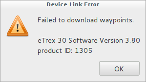
Again this turned out to be a known problem [2] and it seems that the Garmin drivers for QLandkarteGT have stalled in development. It may be that the USB mass storage mode is considered "good enough" to not bother in reverse engineering the proprietary protocol anymore.
Ok, so my usual workflow of opening the "LOC waypoint file" from
geocaching.com in QLandkarteGT and downloading it to the device does
not work anymore. The forum posts indicated that through the USB mass
stroage protocol it should be enough to place GPS data into the
garmin/GPX/ folder on the SD card of the device. It turned out
however that this does not work for the .loc files that can be
downloaded from the free geocaching account. The Garmin device needs
a "GPX" file. So what exactly is the difference and how can I convert
it?
Some trial and error shows that QLandkarteGT can export its geodata as
a .gpx file and automatically uses the correct XML schema for this
file extension. So this leads to the following workflow:
Download .loc files from geocaching.com
Import them into QLandkarteGT by "add geodata"
Repeat previous items for all geocaches
Export all caches in one go to
gc.gpxCopy this file to
garmin/GPX/on the sd card
I'm sure that one can also use gpsbabel for the conversion step,
but this is left as an excercise for the reader.
Comments
Comments powered by Disqus