DEM data for QMapShack
As noted in my previous post GPX Downloads from geocaching.com I still need to rework my workflows from QLandkarteGT to the new QMapShack tool as only the latter is available for a Debian Buster system.
For my use cases, knowing the height of a map location is very important and so providing QMapShack with digital elevation data (DEM for short) is an important step. I cannot remember exactly how I did this for QLandkarteGT in the past, but I remember a lot of web browsing to find and download the correct Shuttle Radar Topology Mission (SRTM) followed by some magic script invocations to package it up for QLandkarteGT. Switching to QMapShack seems like a good time to reevaluate how this can be done most easily.
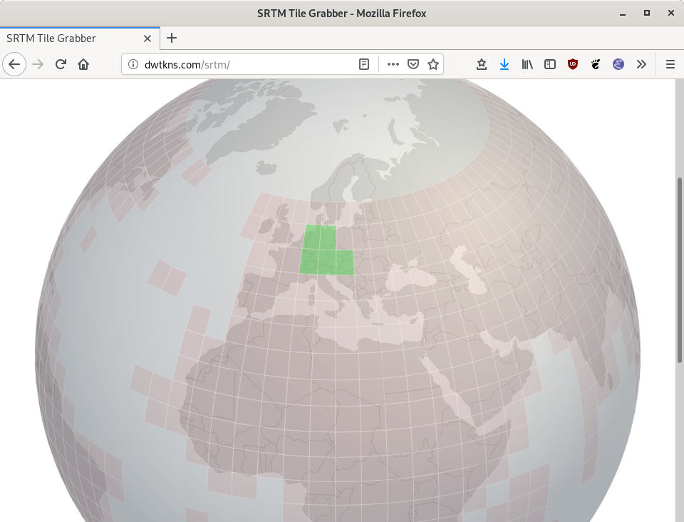
It turns out that downloading the data has become a breeze. The SRTM Tile Grabber is a nice interface to pick and download individual tiles. In the screenshot I downloaded 5 tiles covering the current region of interest:
dzu@krikkit:~$ ls -lh ~/Downloads/srtm_*
-rw-r--r-- 1 dzu dzu 16M Jul 24 09:49 /home/dzu/Downloads/srtm_38_02.zip
-rw-r--r-- 1 dzu dzu 37M Jul 24 09:50 /home/dzu/Downloads/srtm_38_03.zip
-rw-r--r-- 1 dzu dzu 18M Jul 24 09:50 /home/dzu/Downloads/srtm_39_02.zip
-rw-r--r-- 1 dzu dzu 36M Jul 24 09:50 /home/dzu/Downloads/srtm_39_03.zip
-rw-r--r-- 1 dzu dzu 31M Jul 24 09:50 /home/dzu/Downloads/srtm_40_03.zip
dzu@krikkit:~$
In QMapShack I already configured the program so that it expects DEM data in the ~/gps/maps/DEM folder. So let's unpack and wrap the data as described in the QMapShack wiki:
dzu@krikkit:~$ cd gps/maps/DEM/
dzu@krikkit:~/gps/maps/DEM$ for f in ~/Downloads/srtm_* ; do unzip -o $f ; done
Archive:  /home/dzu/Downloads/srtm_38_02.zip
  inflating: readme.txt
  inflating: srtm_38_02.hdr
  inflating: srtm_38_02.tfw
  inflating: srtm_38_02.tif
Archive:  /home/dzu/Downloads/srtm_38_03.zip
  inflating: readme.txt
  inflating: srtm_38_03.hdr
  inflating: srtm_38_03.tfw
  inflating: srtm_38_03.tif
Archive:  /home/dzu/Downloads/srtm_39_02.zip
  inflating: readme.txt
  inflating: srtm_39_02.hdr
  inflating: srtm_39_02.tfw
  inflating: srtm_39_02.tif
Archive:  /home/dzu/Downloads/srtm_39_03.zip
  inflating: readme.txt
  inflating: srtm_39_03.hdr
  inflating: srtm_39_03.tfw
  inflating: srtm_39_03.tif
Archive:  /home/dzu/Downloads/srtm_40_03.zip
  inflating: readme.txt
  inflating: srtm_40_03.hdr
  inflating: srtm_40_03.tfw
  inflating: srtm_40_03.tif
dzu@krikkit:~/gps/maps/DEM$ gdalbuildvrt dach.vrt *.tif
0...10...20...30...40...50...60...70...80...90...100 - done.
dzu@krikkit:~/gps/maps/DEM$
The final step could also be done from the "VRT Builder" menu through a GUI, but this would take a lot more to describe than simply to show the easy command line interface.
Having the DEM data available, a right click in the "DEM Data" window in QMapShack allows to refresh available data sources. Having done that, the data shows up and more options are available in the sub menu that opens clicking on the small triangle:
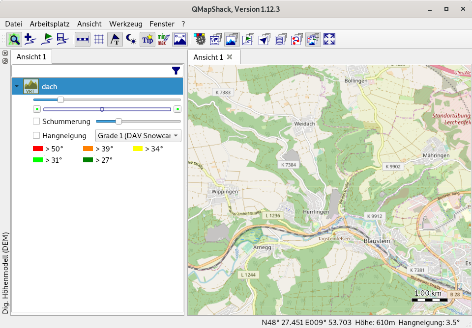
To visually overlay the height data, simply activate "Schummerung":
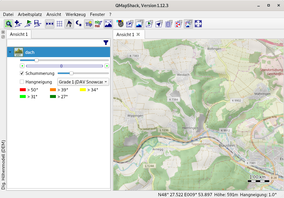
As can be seen in the screenshots, with available DEM data, QMapShack will not only display the height in the lower right hand corner, but also the largest inclination at the cursor position. This is very useful for interactive exploration and for planning activities.
Update 2020-05-04
The same site now also has a downloader for the 30-meter resolution data as compared to the 90-meter resolution offered by the URL above.
While here I also fixed the links for QMapShack as it migrated from Bitbucket to GitHub.
Comments
Comments powered by Disqus